

Storm Amy has begun sweeping across the UK, with weather maps turning deep purple as forecasters warn of gusts up to 97mph, widespread rain, and severe disruption. The Met Office has issued multiple amber and yellow warnings, in force from Friday through Saturday, covering much of Scotland, Northern Ireland, northwest England and Wales.
The storm, fuelled by Atlantic systems and linked to the remnants of Hurricanes Imelda and Humberto, is expected to bring one of the most powerful autumn weather events in recent years. Meteorologists say that damaging gusts of 80-100mph are possible in western Scotland, with Skye, Tiree, Barra and Lochaber particularly at risk.
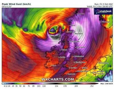 Here is a list of regions expected to be hit the worst by Storm Amy each day: Friday, October 3
 6pm - Western Scotland: Storm Amy slams into the Hebrides and Highlands with gusts topping 85mph.
10pm - Northern Scotland: Stornoway, Wick, and Inverness see gusts close to 90mph.
Saturday, October 46am - Northern Ireland and Western Scotland: Belfast, the western Highlands, and Argyll are battered by gusts up to 97mph.
3pm - Northern England and Southern Scotland: Newcastle, Edinburgh, and the Borders are struck by inland gusts around 80-85mph.
Sunday, October 58am - Wales and the West Country: Cardiff, Swansea, and Plymouth face 75-85mph winds.
11pm - Midlands and Northern England: Birmingham, Manchester, and Leeds are hit by violent gusts late in the evening.
Monday, October 67am - South East England: London, Kent, and Sussex see 65-75mph winds.
2pm - East Anglia: Norfolk and Suffolk coastlines endure one final blast of gusts near 70mph.
"Storm Amy will be an impactful autumn storm for many," warned Met Office Chief Forecaster Neil Armstrong.
"The strongest winds could bring power cuts, damage to buildings and trees, and make coastal areas particularly dangerous."
Alongside the high winds, forecasters warn of 30-50mm of rain in just a few hours across western Scotland, heightening the risk of flooding and even landslides.
The British Geological Survey has said that rainfall totals could be enough to destabilise slopes, threatening communities in already isolated areas.
The Scottish Environment Protection Agency (SEPA) has also raised concerns about dangerous coastal conditions, particularly in the Firth of Clyde, where wave overtopping and flooding may affect homes and infrastructure.
"We urge the public to stay away from exposed coastlines," SEPA's Flood Duty Manager David Morgan said.
Transport networks are braced for disruption. Transport Scotland has warned of difficult driving conditions, potential ferry cancellations and rail delays, while air travel may also be affected. Motorists are advised to check routes before setting off and avoid unnecessary travel in the warning areas.
While Storm Amy is expected to ease gradually on Saturday evening, forecasters say further unsettled weather could continue into next week, with colder, showery conditions replacing the storm.
The UK has recorded October gusts above 100mph before, but forecasters say Amy could rival some of the strongest autumn storms on record.
You may also like

'Protect scientific research': Top NIH scientist fired after whistleblower complaint; who is Dr Jeanne Marrazzo?
Tasha Ghouri lands huge Strictly Come Dancing presenting role on 2025 series
PM Modi to launch Rs 1,000 monthly allowance for 5 lakh graduates, open skill university in Bihar
Karur stampede: Madras HC denies anticipatory bail for TVK leaders Anand and CTR Nirmalkumar
Navi Mumbai To Host India's First Global Capability Centre City, Maharashtra Govt Signs MoU With ANSR


